BirdsEye

BirdsEye GPS

Are you looking for a GPS activity tracker that does not require you to create an online account?
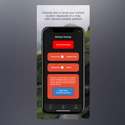
With BirdsEye GPS your activity data exists only on your device unless YOU decide to share it with others.

Have more fun while you exercise!

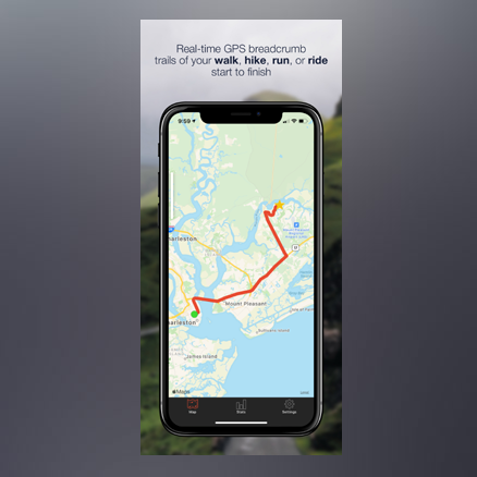
  • View real-time GPS breadcrumb trails of your walk, hike, run, or ride
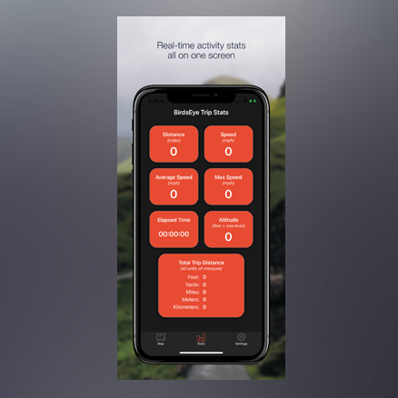
  • Keep track of the roads and areas you have travelled, as well as areas that you have not yet explored
  • BirdsEye GPS generates GPX files that can be uploaded to Strava and shared with friends and fellow activity group members
  • Generate a route plan for all to follow during group activities
  • Works on Apple iPhone and iPad
Map page features

Map page features

  • Real-time GPS tracking and breadcrumb trails
  • On-map distance and speed display
  • Shows Starting Point (with address if available), Current Location (with address if available), as well as your route travel path
  • Pinch to zoom in or out on the map
  • Tap the map to center it on your current location
  • Map can be viewed in Street View or Satellite View
Stats page features

Stats page features

  • Shows total distance travelled, current speed, average speed, maximum speed, elapsed time, and current altitude
  • Long Press to reset Elapsed Time, Average Speed, and Max Speed to zero
  • View readings as US/Imperial or Metric
  • View total distance travelled in feet, yards, miles, meters, and kilometers all in one place
Settings page features

Settings page features

  • Pause and Resume GPS recording
  • Select between map style of Street View or Satellite View
  • Select between US/Imperial or Metric readings display
  • Send your current location to someone via text message or email. This can be useful if you need someone to pick you up or to share your progress during an outdoor activity
  • Save your activity details (travel route) to a GPX file and store it on your device or in the cloud
  • Share your GPX file with friends and fellow activity group members via text message or email. They can then import the file into the BirdsEye app on their device and use it as a route plan to follow
  • Import up to 10 GPX files into your BirdsEye map. You can color-code each of the 10 map overlays, or make them all the same color. You can import GPX files (route plans) supplied by other people
  • Upload your GPX file to Strava. Once the file has been uploaded to Strava you can add additional activity details, attach photos taken during your activity, and use the Strava social features to share with your family and friends

Instructions

  1. After installing the app and opening it for the first time you will see a popup stating "Allow BirdsEye to use your location?". Tap on the "Allow While Using App" option
  2. A little while later you will see a second popup stating "Allow BirdsEye to also use your location even when you are not using the app?". Tap on the "Change to Always Allow" option. This is recommended as it will enable the app to record your location even if the screen is locked or if other apps are in the foreground. If you do not select the "Change to Always Allow" option the readings will not be captured any time the BirdsEye app is not visible on the screen
  3. You can update the BirdsEye Location preference settings at any time by selecting the gray Settings gear icon on your device, then select BirdsEye, then select Location, and make any necessary changes
  4. The app starts recording your location details right away when you open the app. GPS recording can be paused and resumed using the big button at the top of the Settings page
  5. The BirdsEye app will stop recording your location and will not consume battery power when you close the app
  6. Closing the app will end the gps recording and will clear all recorded information, so please be certain to Save or Share your GPX file before closing the app

Useful Tip: You can manually create a route map to follow by using the GPX Generator website. You can then import the route map into your BirdsEye app. (We are not affiliated with that site, but you may find it to be useful)
Follow these steps to manually create a route map:

  1. Using a computer, open a Chrome browser and go to https://www.gpxgenerator.com and click the "Move to current location" button
  2. Click on the map multiple times to add all of the pins needed to map out your route
  3. Click the "Generate GPX" button and select and copy all of the generated xml code
  4. Paste the copied code into Notepad (or similar text editor) and save the file with a name and change the file extension to .gpx (for example: "MyRiverRide.gpx")
  5. Email the saved file to yourself so you can retrieve and save it to your phone or tablet
  6. Open your BirdsEye app, go to the Settings page, select a color in the Import section, and then import the GPX file. You route map will now show up on your BirdsEye map!

Happy adventures!!

Get in touch

Please feel free to contact us with any BirdsEye GPS app feature requests and feedback you may have.